![Early days: Map of “Proposed Comprehensive Rapid Transit Plan,” June 1920. (Courtesy of New York Transit Museum)](https://cdn.viewing.nyc/assets/media/f212a0e3f326480b2fbecea7255170db/elements/881f4b47af9bdd695dfe83d7e09c7b98/xl/d6d55326-3e0a-4d95-b26e-e02bafd27a35_2x.png)
![Detail shows proposed subway tracks on Third Avenue and existing elevated tracks on Third and Second.](https://cdn.viewing.nyc/assets/media/dc075e33392a73ac6c58ce573afa0ed1/elements/9ad77516824a4a1095a3720346947367/xl/dffe513c-ad65-4c60-9ba1-4cf86a974e3a_2x.png)
![Mid-century modern: “Proposed Second Avenue Trunk Line,” June 1950. (Courtesy of New York Transit Museum)](https://cdn.viewing.nyc/assets/media/0c9a93d54fd3d4924426efccef882d34/elements/b0f12b3ef98750f5eeaba26cec1a5d9d/xl/c7fa4768-9242-455f-ad15-ebef2c7da2e2_2x.png)
![Sorry, village people.](https://cdn.viewing.nyc/assets/media/46cc22ffba64ea8202cc602a19b2f183/elements/84551e1eff7682a8d6905f5140c5ff34/xl/6a19ff6b-443b-4d36-a51f-2f3eacaadc5d_2x.png)
![Reconfigured: “Recommended Routes and Connections to the 63rd St. Tunnel,” October 1968. (Courtesy of New York Transit Museum)](https://cdn.viewing.nyc/assets/media/c6ab63273230fc3f52ea2e95f891808e/elements/d09f81cc28aac05468b8a02cbd248b7c/xl/8d201ffc-a1f9-4d49-a506-022994566f9e_2x.png)
![Austerity strikes: “Rapid Transit Route 132-C Second Avenue General Location Map,” June 1973. (Courtesy of New York Transit Museum)](https://cdn.viewing.nyc/assets/media/6a9ba8113c01f8e46be99acf4df8f6f0/elements/f089bbe95abb0b6dd808737f2c860234/xl/efc68b87-6a95-4490-b9fd-50ac500422f2_2x.png)
![Finally. (Metropolitan Transportation Authority of New York City)](https://cdn.viewing.nyc/assets/media/cd79c9d0163d69bdcf0fe6713ef1b44b/elements/8297bbb13a8c889b96197e2989cf7592/xl/6916790a-6fcf-4413-864a-83f7fef16c70_2x.png)
![](https://cdn.viewing.nyc/assets/media/f212a0e3f326480b2fbecea7255170db/elements/881f4b47af9bdd695dfe83d7e09c7b98/xs/d6d55326-3e0a-4d95-b26e-e02bafd27a35_2x.png)
![](https://cdn.viewing.nyc/assets/media/dc075e33392a73ac6c58ce573afa0ed1/elements/9ad77516824a4a1095a3720346947367/xs/dffe513c-ad65-4c60-9ba1-4cf86a974e3a_2x.png)
![](https://cdn.viewing.nyc/assets/media/0c9a93d54fd3d4924426efccef882d34/elements/b0f12b3ef98750f5eeaba26cec1a5d9d/xs/c7fa4768-9242-455f-ad15-ebef2c7da2e2_2x.png)
![](https://cdn.viewing.nyc/assets/media/46cc22ffba64ea8202cc602a19b2f183/elements/84551e1eff7682a8d6905f5140c5ff34/xs/6a19ff6b-443b-4d36-a51f-2f3eacaadc5d_2x.png)
![](https://cdn.viewing.nyc/assets/media/c6ab63273230fc3f52ea2e95f891808e/elements/d09f81cc28aac05468b8a02cbd248b7c/xs/8d201ffc-a1f9-4d49-a506-022994566f9e_2x.png)
![](https://cdn.viewing.nyc/assets/media/6a9ba8113c01f8e46be99acf4df8f6f0/elements/f089bbe95abb0b6dd808737f2c860234/xs/efc68b87-6a95-4490-b9fd-50ac500422f2_2x.png)
![](https://cdn.viewing.nyc/assets/media/cd79c9d0163d69bdcf0fe6713ef1b44b/elements/8297bbb13a8c889b96197e2989cf7592/xs/6916790a-6fcf-4413-864a-83f7fef16c70_2x.png)
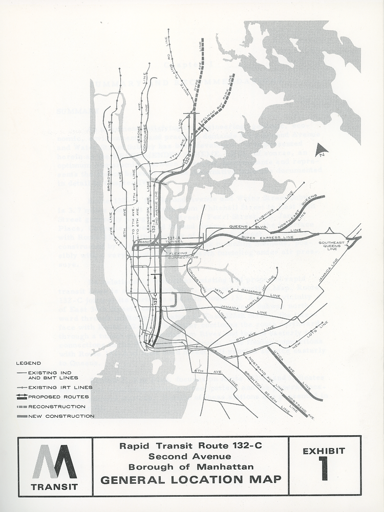
A recent article in The Atlantic's excellent CityLab site explorews the history of the Second Avenue Subway, on the eve of its long-awaited opening, as told through vintage maps which incorporated a version of the century-planned subway line.
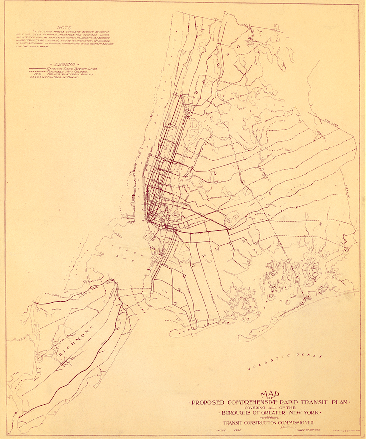
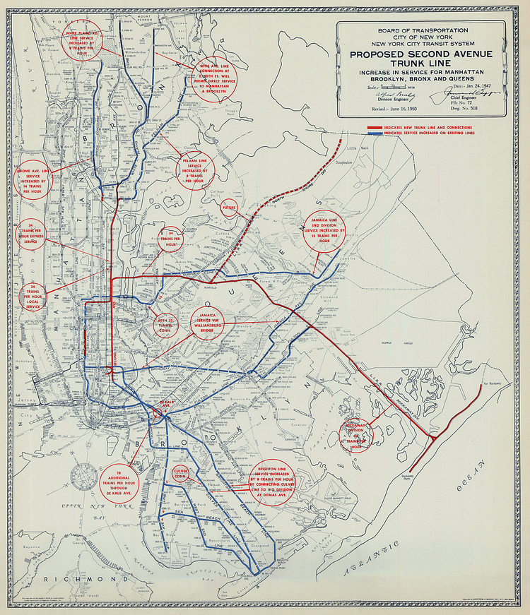
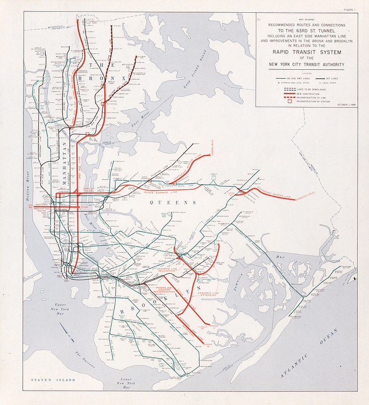
The Second Avenue Subway’s lack of existence is part of New York City lore; like the specters of the Lower Manhattan Expressway and the old Penn Station, it haunts the city with what could have been. Historic maps from the New York Transit Museum show how transportation planners dreamed, schemed, and dreamed again through countless setbacks and financial crises.
Check out the full article for context and descriptions of these maps.
via Citylab
Something wrong with this post? Let us know!